Dark Mode

Rio Carnival Street Blocks Location Data
Data Science and Analytics
Tags and Keywords
Trusted By


"No reviews yet"
Free
About
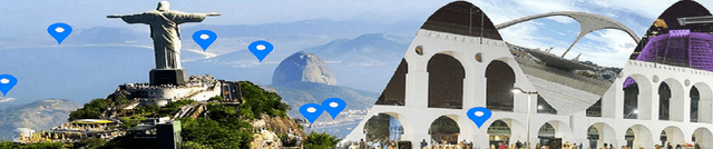
Provides logistics and location data for the 2018 Street Carnival in Rio de Janeiro, focusing on the specific areas and names of the various carnival blocks. The objective of this compilation is to enable users to track and analyse the flow and scheduling of these major public gatherings.
Columns
The dataset is structured across 12 columns, detailing aspects of the event schedule and location.
- Bloco: The specific name of the Carnival block.
- Bairro: The neighbourhood where the event is scheduled (Note: A significant portion of data is missing here).
- Região: The region of Rio de Janeiro (Note: Over half the recorded values are missing).
- Data: The specific calendar date of the event.
- Data Relativa: A description of the date relative to the main carnival days.
- Concentração: The planned start time for the gathering (Note: All values are missing for this column).
- Desfile: The planned start time for the parade (Note: All values are missing for this column).
- Final: The planned end time for the event (Note: All values are missing for this column).
- Local da Concentraçao: The exact location designated for the start of the event (Note: Almost all values are missing).
- Percurso: The planned route of the bloco (Note: Almost all values are missing).
- Público Estimado: The estimated public attendance (Note: All values are missing for this column).
- Ano do primeiro desfile: The year the block first paraded (Note: All values are missing for this column).
Distribution
The information is provided in CSV format and includes 12 distinct columns. While the exact total record count is not available, the dataset lists 385 unique Carnival blocks. The expected update frequency for this specific 2018 data is Never. Users should be aware that several key logistical fields related to timing and estimated audience contain no valid entries.
Usage
Ideal applications include developing maps or applications for tourists visiting Rio de Janeiro, performing geospatial analysis of cultural event distributions, or researching urban event management and planning for large public gatherings.
Coverage
The geographic scope covers various locations within Rio de Janeiro, Brazil. The temporal coverage is limited exclusively to the events scheduled during the 2018 Carnival season.
License
CC0: Public Domain
Who Can Use It
- Geospatial Analysts: For mapping and studying the concentration of cultural events.
- Travel App Developers: To incorporate event locations into travel planning tools.
- Researchers: To analyse the scale and spread of street carnival logistics.
- Bloggers and Journalists: To create content related to Brazilian cultural heritage and travel.
Dataset Name Suggestions
- Rio Carnival Street Blocks Location Data (2018)
- Geospatial Agenda of Rio Blocos (2018)
- Carnival 2018 Block Location Registry
Attributes
Original Data Source: Rio Carnival Street Blocks Location Data
Loading...