Dark Mode

Grand Duchy Highway Flow Data
Data Science and Analytics
Tags and Keywords
Trusted By


"No reviews yet"
Free
About
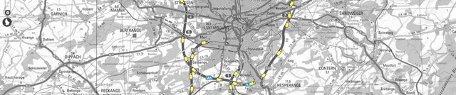
Detailed measurements and monitoring of motorway traffic conditions are provided for the Grand Duchy of Luxembourg. This data was collected using a sophisticated network of over 180 fixed cameras situated across the national highways. The information, supplied by the Administration des Ponts et Chaussées, offers vital insights into vehicle speed and flow metrics. It is essential for understanding the high traffic volumes and regular congestion often caused by the large daily influx of more than 200,000 cross-border commuters travelling to the region.
Columns
id: Unique identifier assigned to the specific camera monitoring the road segment.time: The timestamp indicating when the measurement was captured.latitude: The geographical latitude coordinate of the camera location.longitude: The geographical longitude coordinate of the camera location.direction: The recorded direction of traffic flow (e.g., from town, to town).road: The identifier for the specific motorway being monitored (e.g., A1, A3, A4, A6, A7, A13, B40).trafficStatus: A classification of the current traffic condition, such as ‘freeFlow’.avgVehicleSpeed: The average speed of vehicles recorded in kilometres per hour (km/h).vehicleFlowRate: The rate of traffic flow, measured as the number of cars passing per hour.trafficConcentration: A measure of traffic density, expressed as a percentage.
Distribution
This product aggregates data captured by 186 cameras. Measurements were logged every five minutes. The data set structure encompasses 10 distinct columns and is typically provided in a machine-readable format such as CSV.
Usage
This data product is suited for several advanced applications, including:
- Time series forecasting to predict future traffic flow volumes.
- Predicting the likelihood and timing of traffic jams based on historical trends.
- Network analysis to study car flow patterns and mobility within the Luxembourgish highway system.
Coverage
- Geographic Scope: Covers traffic along the main motorways of Luxembourg, including the A1, A3, A4, A6, A7, A13, and B40 highways.
- Time Range: The collected data spans a period from 19 November 2019 through 26 December 2019.
- Availability: Real-time data is typically logged every five minutes, and this aggregated product is expected to receive annual updates.
License
CC0: Public Domain
Who Can Use It
Intended users include transportation modellers seeking to optimise road usage, data scientists building predictive models for urban mobility, and urban planners analysing the impact of commuter traffic. Researchers interested in time series prediction and network analysis will find this data highly relevant.
Dataset Name Suggestions
- Luxembourg Motorway Traffic Metrics 2019
- Grand Duchy Highway Flow Data
- Administration des Ponts et Chaussées Traffic Observations
- CITA Real-Time Traffic Data Aggregation
Attributes
Original Data Source:Grand Duchy Highway Flow Data
Loading...