Dark Mode

National Road Network of Australia
Data Science and Analytics
Tags and Keywords
Trusted By


"No reviews yet"
Free
About
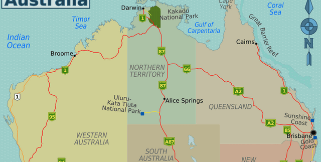
A digital representation of Australia's major road network, this dataset offers an optimised national view of road geometry and attribution. It is a filtered subset of the National Roads dataset, focusing on highways, arterial, and sub-arterial roads that are currently operational. The data is aggregated from multiple jurisdictional sources and is designed for visualisation, analysis, and logistics planning on both national and local scales. The scope covers the land mass of Australia and its offshore islands, with the exception of Norfolk Island. It includes linear features for land-based transportation routes and vehicle-carrying ferry routes but excludes railways, tramways, and driveways.
Columns
- OBJECTID: A sequential identifier for each feature in the dataset.
- ID: Persistent identifier for a roads feature.
- road_id: Another persistent identifier for a road feature.
- contributor_id: The identifier for a road segment provided by the original data contributor.
- jurisdictional_control: The state or territory authority responsible for the road.
- operator: The entity that operates the road.
- date_created: The date the road feature was first created in the custodian's system.
- date_modified: The date the record was last updated.
- national_route: The route number for a road of national significance (e.g., A1).
- state_route: The route number for a road of state significance (e.g., B100).
- full_street_name: The complete official name of the road, combining name, type, and suffix.
- street_name: The primary name of the road.
- street_name_label: The road name in title case.
- street_type: The classification of the road, such as 'Street' or 'Highway'.
- street_type_label: The road type in title case.
- street_suffix: A directional or positional suffix for the road name (e.g., WEST).
- street_suffix_label: The road suffix in title case.
- street_alias_name: An alternative or secondary name for the road.
- street_alias_type: The type associated with the alias name.
- street_alias_suffix: The suffix associated with the alias name.
- feature_type: Classification based on physical characteristics, like 'MOTORWAY'.
- hierarchy: The road's classification, such as 'ARTERIAL ROAD'.
- subtype: Further physical classification, such as 'BRIDGE' or 'ROUNDABOUT'.
- ground_relationship: The road's vertical position relative to the ground (e.g., ON GROUND).
- lane_count: Total number of physical lanes.
- lane_description: Description of the lane count, such as 'TWO OR MORE'.
- one_way: Indicates if traffic is one-way or two-way.
- status: The lifecycle stage of the road, e.g., 'OPERATIONAL'.
- surface: The road surface material, typically 'SEALED' or 'UNSEALED'.
- trafficability: The minimum vehicle type advised for the road, e.g., '2WD'.
- travel_direction: The permitted direction of vehicle travel.
- speed: The posted speed limit for the road section.
- state: The state or territory abbreviation.
- source: The primary data source, typically the state or territory.
- horizontal_accuracy: The horizontal accuracy of the feature in metres.
- Shape__Length: The geometric length of the line feature.
Distribution
The dataset is available as a single CSV file named
MajorRoads.csv with a size of 138.11 MB. It contains 35 columns and approximately 517,000 records.Usage
This data is ideal for applications requiring detailed road network information. Key use cases include:
- Geospatial analysis and network routing.
- Logistics planning and supply chain optimisation.
- Infrastructure planning and management.
- Urban and regional development studies.
- Transportation modelling and traffic analysis.
- Cartographic visualisation and map creation.
Coverage
The dataset's spatial extent covers the entirety of Australia's land mass and offshore islands, from West 96° to East 160° longitude, and from South -44° to North -9° latitude. Norfolk Island is not included. The data is current as of February 2024 and is updated on a monthly basis. It includes roads with an operational status and specific hierarchy values (National or State highway, arterial, or sub-arterial).
License
Attribution 4.0 International (CC BY 4.0)
Who Can Use It
- Logistics Companies: For optimising delivery routes and fleet management based on road hierarchy, speed limits, and trafficability.
- Urban Planners: To analyse road infrastructure, plan new developments, and assess transportation accessibility.
- Government Agencies: For infrastructure management, emergency response planning, and policy-making.
- GIS Analysts and Data Scientists: For conducting spatial analysis, creating transport models, and developing location-based applications.
- Academic Researchers: To study transportation networks, geographic patterns, and environmental impacts.
Dataset Name Suggestions
- Australia Major Road Network
- Australian Arterial Roads and Highways
- Geoscape Australian Major Roads
- National Road Network of Australia
- Australia Logistics & Transport Roads
Attributes
Original Data Source: National Road Network of Australia
Loading...