Dark Mode

Spain Hydrographic Balance and Geospatial Data
Data Science and Analytics
Tags and Keywords
Trusted By


"No reviews yet"
Free
About
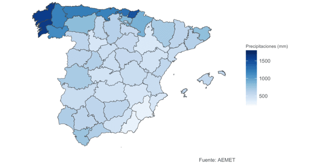
Precipitation statistics regarding the hydrographic balance of the Spanish peninsular territory are provided in this dataset. The data originates from the State Meteorological Agency (AEMET), the public body responsible for meteorological and climate management in Spain, and specifically focuses on precipitation levels organised by province. Additionally, to facilitate accurate representation of the territory, the dataset includes basic topographic data such as municipal, provincial, and autonomous boundaries provided by the National Centre for Geographic Information (CNIG).
Columns
- Parametro: The meteorological parameter measured, specifically "Precipitaciones" (Precipitation).
- periodo de referencia: The base reference interval for the data, identified as 1981-2010.
- region: The specific Spanish territory or province (52 unique values).
- enero - diciembre: Monthly precipitation values for each month from January to December.
- anual: The total annual precipitation value.
Distribution
The primary data file is titled
PREC_1981_2010_Provincias.csv and contains 52 unique records corresponding to Spanish provinces. The file size is approximately 5.34 kB. Additionally, the distribution includes shapefiles (.shp) containing autonomous distributions necessary for mapping the territory. The update frequency for this dataset is expected to be never.Usage
This dataset is ideal for carrying out Exploratory Data Analysis (EDA) and Data Visualization projects. It allows for the study of hydrographic balances and climate patterns across different regions of Spain. The inclusion of geospatial files makes it suitable for performing Geospatial Analysis. It is also explicitly tagged for use with R and Tidyverse workflows.
Coverage
Geographically, the data covers the peninsular territory of Spain, broken down by province. The temporal coverage refers to the specific reference period of 1981-2010. The data includes all 52 provinces/regions with a 100% valid value rate for the primary keys.
License
Attribution 4.0 International (CC BY 4.0)
Who Can Use It
- Climatologists and Meteorologists: For analysing historical precipitation patterns in Spain.
- Data Scientists: For practising geospatial analysis and visualisation techniques using R or other tools.
- Geographers: For mapping hydrographic data against topographic boundaries provided by the CNIG.
- Students: For learning data manipulation with the Tidyverse library.
Dataset Name Suggestions
- Spanish Peninsular Precipitation Balance 1981-2010
- AEMET Precipitation Statistics by Province
- Spain Hydrographic Balance and Geospatial Data
- Monthly Precipitation Spain 1981-2010
Attributes
Original Data Source: Spain Hydrographic Balance and Geospatial Data
Loading...