Dark Mode

NZ Road Incident System Log
Data Science and Analytics
Tags and Keywords
Trusted By


"No reviews yet"
Free
About
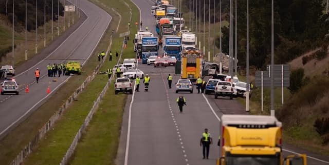
Detailed analytical insights into traffic crash outcomes across New Zealand, spanning from the year 2000 to the present day. The information is derived from the official Crash Analysis System (CAS) data, collected and managed by the Waka Kotahi NZ Transport Agency. This data product is essential for research and analysis focused on road safety trends, providing key variables related to crash circumstances, severity (fatal, serious, minor, non-injury), geographical location, vehicle types involved, and prevailing road and environmental factors. The data is aggregated and does not contain personal information.
Columns
The dataset features 72 distinct variables capturing the attributes of reported traffic incidents. Key analytical columns include:
- crashSeverity: The outcome based on the worst injury sustained in the incident (Fatal, Serious, Minor, Non-injury).
- fatalCount / seriousInjuryCount / minorInjuryCount: Numerical counts of casualties by injury classification.
- crashYear / crashFinancialYear: Temporal markers allowing for time-series analysis.
- easting / northing: Geographic coordinates (NZMG, WGS84 datum) defining the crash location, though some crashes lack assigned GPS data.
- speedLimit: The legal speed limit enforced at the crash site.
- trafficControl: Details on signals present at the location (e.g., Traffic Signals, Stop Sign, Give Way Sign, Nil).
- weatherA / weatherB: Environmental conditions at the time of the incident (e.g., Fine, Light Rain, Strong Wind).
- carStationWagon / truck / motorcycle / pedestrian / bus: Derived count variables indicating the number of specific types of vehicles or parties involved.
- roadSurface: Descriptive variable indicating whether the road was Sealed or Unsealed.
Distribution
This product contains approximately 870,000 records detailing individual traffic crashes. The data is structured for analytical use, typically provided in a CSV file format, with a file size around 243.7 MB. The source data is generally updated on a monthly basis.
Usage
This data product is perfectly suited for modelling traffic safety risk, identifying high-risk geographical zones, evaluating the efficacy of road safety policies, and understanding factors contributing to crash severity. Ideal applications include academic research on transportation safety, urban planning requiring geospatial analysis of incidents, and public policy formulation aimed at infrastructure improvements.
Coverage
The geographic scope covers all traffic crashes reported within New Zealand. The temporal scope ranges from January 1, 2000, to the most recent month of reporting. It is important to note that full data processing times can vary significantly based on crash severity; for instance, non-injury crashes may have a data lag of up to seven months. Furthermore, records for recent years, specifically 2020 and 2021, have been noted as possibly incomplete.
License
Creative Commons Attribution 4.0 International (CC BY 4.0) License
Who Can Use It
- Data Scientists: For developing predictive algorithms related to crash occurrence and severity outcomes.
- Road Safety Researchers: To analyse the relationships between weather, road features (like guard rails or kerbs), and incident rates.
- Urban Planners: To inform decisions regarding traffic flow management, intersection design, and public transport routing, particularly in areas like Auckland where crash counts are high.
- Insurance Professionals: To refine risk assessments and pricing structures based on detailed, verifiable incident data.
Dataset Name Suggestions
- New Zealand Traffic Crash Analysis Data
- NZ Road Incident System Log
- Road Safety Records from Waka Kotahi
- New Zealand Traffic Incident Trends
Attributes
Original Data Source: NZ Road Incident System Log
Loading...