Dark Mode

United States County-Level Agricultural Chemical Data
Data Science and Analytics
Tags and Keywords
Trusted By


"No reviews yet"
Free
About
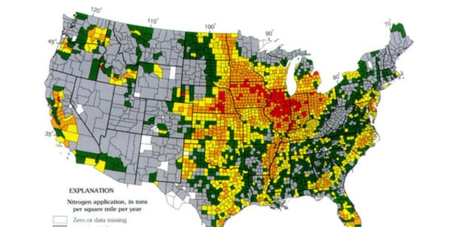
Vital estimates of agricultural pesticide usage across the United States are provided in this file, derived from the US Geological Survey's National Water-Quality Assessment Project. The records span nearly three decades, offering insights into chemical application trends based on proprietary farm operation surveys. Detailed metrics include both high and low usage estimates (in kilograms) categorised by county, specific chemical compound, and year, enabling robust temporal and geospatial analysis of agricultural inputs.
Columns
- COMPOUND: Identifies the specific chemical substance applied (e.g., Glyphosate).
- YEAR: The calendar year in which the measurement was recorded (spanning 1992 to 2019).
- STATE_FIPS_CODE: Numerical Federal Information Processing Standard code representing the US state.
- COUNTY_FIPS_CODE: Numerical Federal Information Processing Standard code representing the specific county.
- EPEST_LOW_KG: The conservative, lower-bound estimate of the pesticide usage in kilograms.
- EPEST_HIGH_KG: The upper-bound estimate of the pesticide usage in kilograms.
Distribution
Presented in a Comma Separated Values (CSV) format, the file
epest_county_estimates.csv contains approximately 9.56 million valid records. The total file size is roughly 303.69 MB, ensuring a substantial volume of historical data is available for detailed processing.Usage
- Environmental Impact Assessment: Analyse the correlation between chemical usage and local water quality or soil health.
- Agricultural Trends: Track the rise and fall of specific compounds, such as Glyphosate, over time.
- Regulatory Policy: Inform decisions regarding chemical bans or restrictions based on historical usage density.
- Market Analysis: Evaluate the demand for specific agrochemicals across different US regions.
Coverage
The data covers the contiguous United States at the county level. The temporal scope extends from 1992 through to the preliminary figures of 2019. It focuses specifically on agricultural operations, aggregating data to provide annual estimates for over 500 unique chemical compounds.
License
CC0: Public Domain
Who Can Use It
- Environmental Scientists: Monitoring ecosystem health and potential pollution sources.
- Agricultural Economists: Studying farming input costs and usage patterns.
- Public Health Officials: Investigating potential exposure risks in specific counties.
- Data Journalists: Visualising the changing landscape of American farming practices.
Dataset Name Suggestions
- USGS National Pesticide Usage Estimates (1992-2019)
- United States County-Level Agricultural Chemical Data
- Historical Agrochemical Application Metrics US
- National Synthesis Project: Pesticide Usage Time Series
Attributes
Original Data Source: United States County-Level Agricultural Chemical Data
Loading...