Dark Mode

Parking Space Occupancy Detection
Data Science and Analytics
Tags and Keywords
Trusted By


"No reviews yet"
Free
About
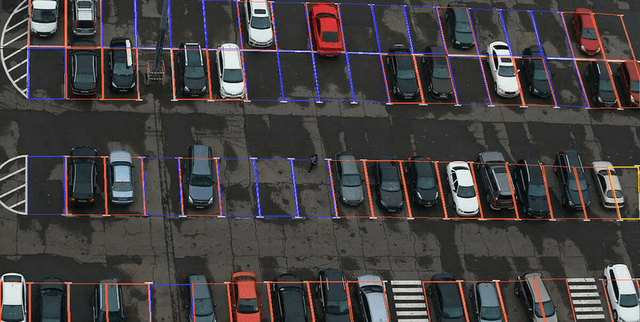
Specifically designed for the classification of parking spaces. It comprises images of parking areas, each accompanied by precise bounding box masks. These masks outline the exact boundaries of individual parking spaces, detailing their position and shape within an image, which facilitates accurate identification and extraction. Every parking spot is also labelled according to its occupancy status: free, not free, or partially free, making it suitable for training models to visually identify parking availability.
Columns
The primary data elements include original images of parking lots and corresponding annotation data. Each image has associated bounding box labels. Within the annotation file, for each identified parking space, x and y coordinates define the points of its bounding box. These bounding boxes are assigned one of three labels:
- free_parking_space: Indicating an available parking spot, typically marked with a blue box in visualisations.
- not_free_parking_space: Signifying an occupied parking spot, usually marked with a red box.
- partially_free_parking_space: Denoting a parking spot that is partially occupied or free, often marked with a yellow box. The dataset also includes logical image-mask pairings.
Distribution
The dataset is structured with images stored in an
images folder, alongside a boxes folder containing bounding box labelling information. Detailed annotations are provided in an annotations.xml file, which contains the coordinates of the bounding boxes and their respective labels for each parking space in the original photos. The annotations.xml file is approximately 204.83 kB. The dataset's Version 1 is around 44.64 MB. The dataset largely consists of image-mask pairings.Usage
This data product can be effectively utilised for a range of applications, including:
- Developing and improving parking lot management systems.
- Enhancing autonomous vehicle navigation capabilities.
- Facilitating the implementation of smart city initiatives.
- Conducting traffic analysis and urban planning.
- Building systems for automatic parking lot detection and parking spot surveillance.
- Creating visual occupancy detection and classification models.
Coverage
Information regarding the specific geographic regions, time ranges, or demographic scope of the data is not available within the provided sources.
License
Attribution-NonCommercial-NoDerivatives 4.0 International (CC BY-NC-ND 4.0)
Who Can Use It
This dataset is ideal for:
- Data scientists and machine learning engineers working on object detection and image classification tasks.
- Developers of smart city technologies aiming to optimise urban infrastructure.
- Automotive industry professionals focused on autonomous driving and parking assistance systems.
- Traffic management authorities and urban planners seeking insights into parking patterns and occupancy.
- Academics and researchers exploring computer vision applications in real-world scenarios.
Dataset Name Suggestions
- Parking Space Occupancy Detection
- Smart Parking Visual Data
- Urban Parking Lot Classification
- Vehicle Parking Spot Annotations
- AI Parking Management Dataset
Attributes
Original Data Source:Parking Space Occupancy Detection
Loading...