Dark Mode

Turkish Regional Earthquake Data
Data Science and Analytics
Tags and Keywords
Trusted By


"No reviews yet"
Free
About
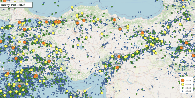
This dataset presents detailed earthquake records for Turkey and its surrounding areas, collected by the Kandilli Observatory and Earthquake Research Institute (KOERI), a renowned Turkish institution for seismic research. It covers a significant period from September 1994 to September 2023, exclusively featuring earthquakes with magnitudes greater than 3.0 on the Richter scale. The dataset serves as a valuable resource for understanding regional seismic activity and historical earthquake patterns.
Columns
- ID: A unique numerical identifier for each earthquake event.
- Deprem Kodu (Earthquake code): An alphanumeric code associated with the earthquake.
- Olus tarihi (Date of earthquake): The calendar date when the earthquake occurred.
- Olus zamani (Time of earthquake): The specific time of day when the earthquake occurred.
- Enlem (Latitude): The geographical latitude coordinate of the earthquake's epicentre.
- Boylam (Longitude): The geographical longitude coordinate of the earthquake's epicentre.
- Der(km) (Depth(km)): The depth of the earthquake's hypocentre, measured in kilometres.
- xM: A measure of earthquake magnitude.
- MD: A specific type of magnitude measurement.
- ML: A local magnitude measurement, often referred to as Richter magnitude.
- Mw: A moment magnitude measurement, indicating the seismic moment of an earthquake. Please note that a significant portion of values in this column are missing.
- Ms: A surface wave magnitude measurement.
- Mb: A body wave magnitude measurement.
- Tip (Type): Categorises the type of seismic event, for example, 'Ke' or 'Sm'.
- Yer (Location): Specifies the geographical location or region of the earthquake, such as 'AKDENIZ' (Mediterranean) or 'EGE DENIZI' (Aegean Sea).
Distribution
The dataset is provided as a CSV file, named
veriler.csv, with a file size of 6.5 MB. It contains 15 columns and consists of approximately 50,000 records. While most columns have complete data for all records, the 'Mw' (Moment Magnitude) column has roughly 26% valid entries, with the remaining 74% being missing values. The dataset is expected to be updated annually.Usage
This dataset is ideal for:
- Seismic Activity Analysis: Investigating patterns, frequencies, and geographical distribution of earthquakes in Turkey and its vicinity.
- Geological Research: Supporting studies on tectonic plate movements, fault lines, and earthquake mechanisms in the region.
- Risk Assessment: Aiding in the analysis of historical seismic data for potential hazard mapping, strictly for non-commercial purposes.
- Educational Purposes: Providing real-world data for academic research and teaching in seismology and earth sciences.
- Historical Data Review: Examining long-term trends and significant seismic events over a 29-year period.
Coverage
The dataset's geographic scope encompasses Turkey and its surrounding regions, including areas such as the Mediterranean and Aegean Seas. Latitude values range from 35 to 42, while longitude values span from 26 to 45. The time range covered is from September 1994 to September 2023. It includes only earthquakes with magnitudes exceeding 3.0 on the Richter scale. Specific notes on data availability include the fact that the 'Mw' column has many missing entries.
License
CC BY-SA 4.0.
Important Notice: All data within this dataset is the property of "Boğaziçi Üniversitesi Rektörlüğü". Its usage is strictly restricted to non-commercial purposes that align with the mission of the "Boğaziçi Üniversitesi Kandilli Rasathanesi ve Deprem Araştırma Enstitüsü Bölgesel Deprem-Tsunami İzleme ve Değerlendirme Merkezi". Commercial use of this data is expressly prohibited.
Who Can Use It
- Academic Researchers: For studies on seismology, geophysics, and natural disaster analysis.
- University Students: For projects, theses, and coursework related to earthquakes and geological phenomena.
- Governmental/Non-profit Organisations: Engaged in earthquake monitoring, disaster preparedness, and public safety initiatives, provided usage remains non-commercial.
- Seismic Analysts: For developing models and understanding earthquake characteristics.
- Geographers and Cartographers: For mapping seismic activity and geographical features.
Dataset Name Suggestions
- Turkey Seismic Event Log (1994-2023)
- Kandilli Observatory Earthquake Records
- Turkish Regional Earthquake Data
- Anatolian Peninsula Earthquake Monitor
- Historical Turkey Earthquake Catalogue
Attributes
Original Data Source: Turkish Regional Earthquake Data
Loading...