Dark Mode

Israel-Palestine Political Violence Data (ACLED)
Data Science and Analytics
Tags and Keywords
Trusted By


"No reviews yet"
Free
About
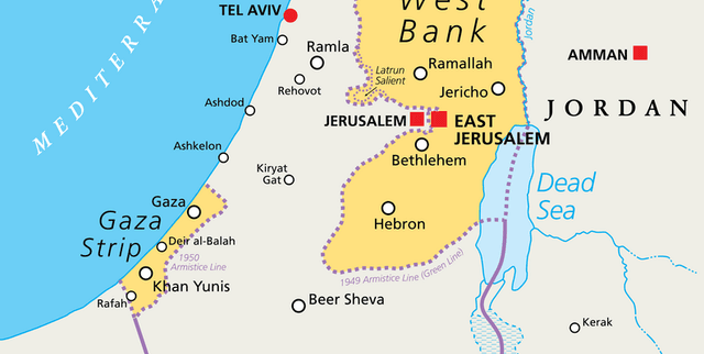
This product delivers disaggregated conflict event data collected by the Armed Conflict Location & Event Data Project (ACLED), an organization dedicated to crisis mapping and detailed conflict data collection. The records focus specifically on reported political violence and demonstration events across the Palestine and Israel regions. The scope covers events such as protests, battles, and instances of violence against civilians. Key metrics recorded include event dates, the primary and associated actors involved, precise geographic locations, and reported fatality counts since the beginning of October 2023.
Columns
event_id_cnty: A unique alphanumeric identifier assigned to each event by number and country acronym.event_date: The specific date the event occurred, noted in Year-Month-Day format.year: The year associated with the event (2023 or 2024).time_precision: A numeric code where a higher value indicates lower certainty regarding the recorded event date.disorder_type: The major category of disorder the event falls into, such as Political violence or Strategic developments.event_type: A specific classification further detailing the nature of the event (e.g., Riots, Explosions/Remote violence).sub_event_type: A detailed subcategory for the event type (e.g., Air/drone strike, Mob violence).actor1: One of the two main parties involved in the recorded event.assoc_actor_1: Any actors involved alongside ‘Actor 1’, or designations that offer further identification.inter1: A numeric code indicating the classification type of ‘Actor 1’.interaction: A two-digit numeric code combining the types of the two interacting actors.civilian_targeting: Indicates whether civilians were the target of the event.iso: The three-digit numeric country code adhering to ISO 3166 standards.region: The global region where the event occurred (Middle East).country: The country or territory where the event took place (Israel or Palestine).admin1,admin2,admin3: Sub-national administrative divisions used to pinpoint the location of the event.location: The common name of the location where the event took place (e.g., Rafah, Gaza City).latitude,longitude: Geographic coordinates of the location in four decimal degrees notation.geo_precision: A numeric code where a higher value signifies lower certainty regarding the recorded location.source: The names of the source reports used to document the event.source_scale: Indicates the geographic proximity of the source material to the event location (e.g., National).notes: A brief textual description of the reported circumstances of the event.fatalities: The reported number of deaths resulting from the event, recorded as the most conservative and reliable estimate available.tags: Additional structured information about the event (e.g., details on crowd size).timestamp: The automatically generated Unix timestamp when the event was uploaded to the ACLED API.
Distribution
The product is available as a CSV file (
2023-10-01-2024-01-29-Middle_East-Israel-Palestine.csv) weighing 9.62 MB. It currently features 28 fields and includes over 18,000 unique event records. The data is regularly updated on a weekly basis.Usage
The data product is ideal for academic research, policy development, and journalistic investigation into the current conflict in the Middle East. It can be used for:
- Geographical mapping of political violence hotspots and frequency.
- Statistical analysis of conflict trends, including shifts in event types (e.g., remote violence versus riots).
- Tracking the involvement and interaction of specific military and non-state actors.
- Analyzing reported civilian targeting incidents over the defined time period.
Coverage
The data covers the geographical regions of Palestine and Israel. The temporal scope spans from October 1st, 2023, up to the end of January 2024. The majority of reported events occur within Palestine, with high concentrations of activity documented in the Gaza Strip and the West Bank. The events recorded focus on all reported political violence and demonstrations, including those involving military entities (such as Military Forces of Israel) and civilians.
License
CC BY-NC-SA 4.0
Who Can Use It
- NGOs and Humanitarian Groups: To monitor violence against civilians and assess ongoing risk levels.
- Geospatial Analysts: To perform advanced crisis mapping and location intelligence analysis.
- Political Scientists: To study conflict typologies and actor dynamics during intense warfare.
- Developers: For building visualizations and real-time conflict tracking applications.
Dataset Name Suggestions
- ACLED Middle East Conflict Events: October 2023–January 2024
- Israel-Palestine Political Violence Data (ACLED)
- Disaggregated Conflict and Event Data: Gaza and Israel (2023–2024)
Attributes
Original Data Source: Israel-Palestine Political Violence Data (ACLED)
Loading...