Intelligent Transportation Vision Dataset
Data Science and Analytics
Tags and Keywords
Trusted By


"No reviews yet"
Free
About
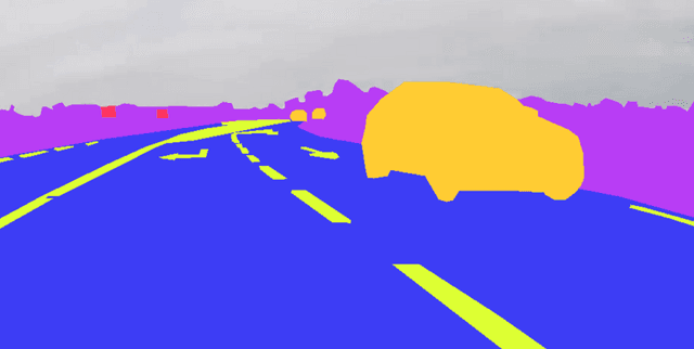
This dataset provides a collection of road images captured using Digital Video Recorders (DVRs). Each image is accompanied by segmentation masks, which precisely delineate different elements within the scene. These elements include the road surface, various cars, road signs, distinct road markings, and the background. The data is highly valuable for developing and improving computer vision algorithms used in road surveillance, navigation, and intelligent transportation systems, as well as for advancing autonomous driving technologies.
Columns
The dataset is structured with original road images and their corresponding segmentation masks. The primary annotation details are found in the
annotations.xml file. This file specifies polygon coordinates (x,y points) and labels for each annotated object within the images. An Image Asset Log lists image_id and image_name for each individual image file.The distinct classes identified within the dataset are:
- road_surface: This represents the traversable area of the road.
- marking: This includes white and yellow lines and symbols present on the road.
- road_sign: This refers to recognisable signs located on or beside the road.
- car: This denotes vehicles present on the road.
- background: This encompasses areas adjacent to the road and surrounding features.
Distribution
The dataset is provided in a structured format, consisting of three main components: an
images folder (containing the original road photographs), a masks folder (holding the segmentation masks for these images), and an annotations.xml file (which contains detailed polygon coordinates and labels). The annotations.xml file has a size of approximately 223.96 kB. The entire dataset, in its Version 2, is approximately 17.01 MB. While a precise total count of records is not specified, the provided logs indicate at least 14 individual image entries are part of the dataset. The expected update frequency for this dataset is noted as 'Never'.Usage
This dataset is well-suited for a variety of applications, including:
- Developing and refining computer vision algorithms.
- Enhancing road surveillance systems.
- Advancing navigation technologies.
- Building intelligent transportation systems.
- Facilitating the development of autonomous driving systems.
- Conducting semantic segmentation research specifically for self-driving cars.
Coverage
The images within this dataset were captured via Digital Video Recorders (DVRs), offering a real-world perspective of road scenes. While a specific geographic location is not provided, the data illustrates typical road environments. A timestamp, "2023-09-10 23:03:19.039854+00:00", is associated with a job related to this data, suggesting its creation or latest update occurred around this time. Demographic information is not applicable to this dataset.
License
Attribution-NonCommercial-NoDerivatives 4.0 International (CC BY-NC-ND 4.0)
Who Can Use It
This dataset is particularly beneficial for:
- Computer Vision Developers: For training and validating image segmentation models.
- Autonomous Vehicle Engineers: For developing and testing perception systems vital for self-driving cars.
- Researchers: In fields such as machine learning, deep learning, and intelligent transportation.
- Urban Planners and Traffic Management Professionals: For analysis of road infrastructure and traffic patterns.
Dataset Name Suggestions
- Road Scene Segmentation Data
- DVR Road Image Segmentation
- Autonomous Driving Road Perception Dataset
- Vehicle and Road Marking Segmentation
- Traffic Scene Semantic Segmentation
Attributes
Original Data Source: Intelligent Transportation Vision Dataset
Loading...
