Dark Mode

Water Level Identification Multi-Sensor Data
Data Science and Analytics
Tags and Keywords
Trusted By


"No reviews yet"
Free
About
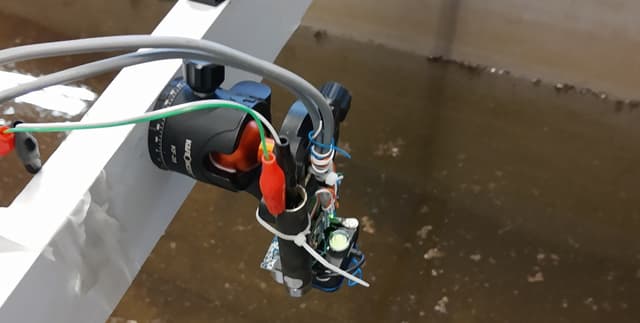
Focuses on advancing accurate water level identification, a vital component of effective flood risk management in urban waterways such as rivers and creeks. The collection facilitates the evaluation of newer technologies, particularly Light Detection and Ranging (LiDAR) sensors. Unlike traditional ultrasonic sensors, LiDAR is less sensitive to adverse weather conditions—such as dust, fog, and rainfall—which frequently accompany flood events. This unique dataset analyses the applicability of LiDAR and evaluates the benefits of a combined sensor approach, merging synchronised data from LiDAR, ultrasonic sensors, and Inertial Measurement Units (IMU), to produce superior predictions using machine learning. The primary goal is to predict the water level based on the readings from the associated variables collected in a controlled environment.
Columns
The dataset contains 15 variables, including sensor measurements and experimental controls:
- id: A row identifier.
- ir_value: The distance measured by the LiDAR sensor.
- ir_strength: The signal strength output from the LiDAR sensor.
- us_value: The distance measured by the ultrasonic sensor.
- acc_x, acc_y, acc_z: Accelerometer readings along the x, y, and z axes from the IMU.
- gyr_acc_x, gyr_acc_y, gyr_acc_z: Gyroscope acceleration data from the IMU.
- gyr_x, gyr_y, gyr_z: Gyroscope rotation data.
- angle: The controlled incidence angle of the measurement device.
- water_level: The target variable representing the actual measured water level.
Distribution
The data is presented in a standard tabular structure, typically distributed in a CSV file format. The collection includes approximately 10,500 valid records.
Usage
This data is ideally suited for developing and evaluating machine learning models, specifically for regression tasks focused on predicting water levels. It can be applied in research exploring the advantages of sensor fusion and comparing the performance metrics of contactless technologies like LiDAR and ultrasonic sensors under varying conditions. The controlled data collection environment makes it excellent for studying the impact of complicating variables, such as incidence angle and water turbidity, on prediction quality.
Coverage
The data was collected in a controlled laboratory environment using an experimental device. Variables such as the incidence angle (ranging from 0 to 10 degrees), distance, and water turbidity were precisely controlled to analyse their effect on predictions. This dataset is static, with an expected update frequency of never.
License
CC BY-SA 4.0
Who Can Use It
- Machine Learning Developers: For building and testing predictive models in environmental monitoring.
- Hydrology Researchers: For assessing the viability of sensor-based systems in urban stream monitoring.
- Electronics Engineers: For studying sensor calibration and data fusion involving LiDAR, ultrasonic, and inertial units.
- Academics and Educators: For demonstrating advanced regression and sensor technology in practical applications.
Dataset Name Suggestions
- Water Level Identification Multi-Sensor Data
- Controlled Sensor Fusion for Hydrology
- LiDAR and Ultrasonic Water Depth Lab Readings
- Urban Stream Flood Monitoring Machine Learning Data
Attributes
Original Data Source: Water Level Identification Multi-Sensor Data
Loading...