Dark Mode

Santiago Pedestrian Collision Geodata 2015
Data Science and Analytics
Tags and Keywords
Trusted By


"No reviews yet"
Free
About
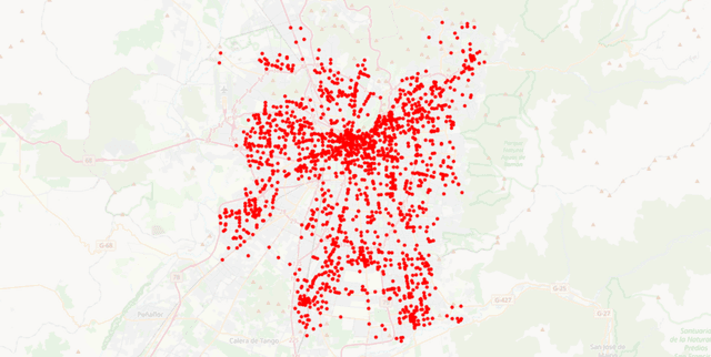
Provides detailed, georeferenced information regarding pedestrian car collisions that occurred in Santiago, Chile, during 2015. This public data set, originating from the Chilean government, is highly valuable for geographical analysis, urban planning, and safety studies focusing on vehicular accidents involving pedestrians.
Columns
X: Latitude coordinate of the collision location (ranging from roughly -70.8 to -70.5).
Y: Longitude coordinate of the collision location (ranging from roughly -33.6 to -33.3).
Ubicacion: The street name or specific textual description of the accident site.
Fallecidos: The count of fatalities resulting from the collision (maximum recorded is 3).
Graves: The count of seriously injured persons (maximum recorded is 4).
MenosGrave: The count of less seriously injured persons (maximum recorded is 2).
Leve: The count of slightly injured persons (maximum recorded is 7).
Accidentes: The recorded number of distinct accidents that have occurred at this precise location (maximum recorded is 8).
Distribution
The data is provided in CSV format, specifically named AtropellosGS2015.csv. It contains 8 distinct columns and 1,841 valid records. The file size is approximately 159.92 kB. The expected update frequency for this specific year's data is never.
Usage
Ideal applications include creating spatial visualisations of collision hotspots, generating statistical models to predict injury severity, informing urban road safety initiatives, and supporting research into accident prevention strategies in major metropolitan areas.
Coverage
The data specifically covers pedestrian car collisions within Santiago, Chile. The temporal scope is limited strictly to the year 2015. The geographic scope is defined by the provided latitude and longitude coordinates for the metropolitan area.
License
CC0: Public Domain
Who Can Use It
Urban planners seeking to identify dangerous intersections and improve city infrastructure. Public safety analysts researching the factors contributing to pedestrian injuries. Government agencies developing targeted accident reduction programs. Researchers focusing on geographical informatics and transport safety.
Dataset Name Suggestions
- Santiago Pedestrian Collision Geodata 2015
- Chile Car Accidents Georeferenced 2015
- Pedestrian Safety Data Santiago 2015
- 2015 Santiago Traffic Injuries Map
Attributes
Original Data Source: Santiago Pedestrian Collision Geodata 2015
Loading...