Dark Mode
AKYS Pathfinder: Vilnius Spatial & Environmental Intelligence LiDAR
Tranportation & Public Transport
Tags and Keywords
£4,999
About
AKYS Pathfinder: Vilnius Spatial & Environmental Intelligence (Dual LiDAR Bundle)
Deterministic Ground Truth with Multi-LiDAR Fusion, Onboard Atmospheric Analytics & 10-DoF Temporal Consistency.
Executive Summary: The Spatial Ground Truth
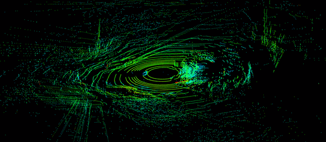
The AKYS Pathfinder series is an enterprise-grade spatial intelligence product designed for high-fidelity 3D mapping, SLAM validation, and digital-twin generation. This flagship bundle features 73 minutes of continuous, hardware-synchronized capture from Vilnius, Lithuania (Feb 17, 2026). It is engineered to provide a "deterministic" reference frame, where every LiDAR point is correlated with precision GNSS-RTK and localized atmospheric conditions.
Core Technical Specifications: The "Core-Sync" Stack
- Dual-LiDAR Fusion: Synchronized Dual Hesai LiDAR sensors delivering a high-density, near-360° horizontal point cloud. This configuration eliminates vehicle blind spots and provides the high vertical resolution necessary for overhead infrastructure audits.
- 10-DoF Navigation Engine: Centimeter-level GNSS RTK fused with a high-frequency 6-axis IMU and magnetic compass. This 10-Degree-of-Freedom stack provides a drift-free ego-trajectory, essential for survey-grade mapping.
- Hardware-Level Synchronization: Every data point from LiDAR pulses to sensor samples is time-stamped via hardware PPS/NTP triggering to ensure zero-drift across all modalities.
Onboard Environmental Intelligence (Atmospheric Ground Truth)
Unlike standard datasets, the Pathfinder series includes a synchronized Environmental Sensing Suite providing per-second logging of localized urban conditions:
- Air Quality Analytics: High-resolution onboard logging of CO2, TVOC, and Formaldehyde (CH2O).
- Particulate Matter (PM): Real-time monitoring of PM2.5 and PM10 levels, allowing for sensor performance correlation in varying air densities.
- Micro-Climate Telemetry: Precision vehicle-mounted sensors capturing Ambient Temperature (-7.0°C range) and Relative Humidity synchronized to the vehicle’s exact GPS position.
Advanced Intelligence & Data Formats
- Standardized Spatial Exports: Data is delivered in structured PCAP, JSON, CSV, and GeoJSON formats for immediate ingestion into ROS-based robotics stacks and high-fidelity simulators (NVIDIA Drive Sim, Carla).
- Refined Ego-Trajectory: A post-processed, precision vehicle path delivered as a machine-readable layer for localization and path-planning research.
- Infrastructure Audit Ready: Optimized for the automated identification of signage defects, road markings, and urban furniture.
Distribution & Commercial Rights
- Volume: ~22 GB Structured archive containing point cloud data, precise trajectories, and environmental metadata.
- Compliance: GDPR-compliant dataset (any associated vision layers undergo production-grade face/plate blurring).
- AI Training Rights: Comprehensive Commercial Rights for LLM/VLM training, SLAM algorithm fine-tuning, and weights commercialization.
- Enterprise Scaling: Additional modules including Thermal LWIR, 360° Fisheye Surround, and Acoustic Profiling are available for this route upon request.
akys.ai
Loading...
£4,999
Download Dataset in Unknown Format
Recommended Datasets
Loading recommendations...