Dark Mode

Geographic Data of Classic Maya Centres
Data Science and Analytics
Tags and Keywords
Trusted By


"No reviews yet"
Free
About
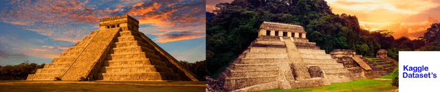
Data concerning Mayan archaeological sites that feature inscriptions, representing a major advanced civilisation of Mesoamerica. This collection details sites where the Maya flourished, primarily covering the period from roughly 250 CE until around 1400. The Maya are noted for their sophisticated written language, mathematics, and astronomy. The sites included, such as Tikal, were major urban centres featuring impressive structures like pyramids. This product provides essential location and identification data for historical and geospatial study of these areas.
Columns
- Name: The primary designation of the archaeological site (100% valid records).
- Alt_Name: Alternate names used for the site, though this field has a high rate of missing values (63% missing).
- Acronym: A short identifying code for the location (12% missing values).
- Country_Area: Specifies the country and the regional area or province where the site is currently situated, such as Guatemala, Petén.
- Latitude: The geographic latitude coordinate of the site (1% missing values).
- Longitude: The geographic longitude coordinate of the site (1% missing values).
Distribution
The data consists of 332 records housed in a single CSV file named
scrapedData.csv. The file size is 24.14 kB and contains 6 fields per record. The data structure is fixed, and there are no expected future updates.Usage
This data product is suited for applications requiring location data for ancient cities. Primary uses include geospatial analysis of Mayan settlement patterns, data visualization projects showcasing the extent of the Classic Maya world, and historical research focusing on site names, locations, and political distribution. It is also valuable for educational purposes concerning Mesoamerican history.
Coverage
The dataset covers 332 identified archaeological sites located within the modern-day boundaries of Mexico, Guatemala, Belize, and Honduras. Geographical regions frequently represented include Guatemala, Petén, and Mexico, Campeche. The data fundamentally maps locations significant to the Classic Maya period.
License
CC0: Public Domain
Who Can Use It
- History Researchers: To investigate the spatial relationships between urban centres and the extent of the Mayan civilisation.
- Educational Content Developers: For creating interactive maps and resources about the Maya's advanced culture and geography.
- Geospatial Analysts: To perform mapping and spatial statistics on ancient urban distribution.
- Data Visualisation Experts: To generate visual representations of historical sites and their relative importance.
Dataset Name Suggestions
- Mayan Inscribed Site Locations
- Geographic Data of Classic Maya Centres
- Atlas of Mesoamerican Archaeology
- Sites of the Maya Civilisation
Attributes
Original Data Source: Geographic Data of Classic Maya Centres
Loading...
Free
Download Dataset in CSV Format
Recommended Datasets
Loading recommendations...