Dark Mode

BR-101 Highway Traffic Incident Data
Data Science and Analytics
Tags and Keywords
Trusted By


"No reviews yet"
Free
About
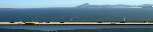
Accident records detail occurrences on the Presidente Costa e Silva Bridge, commonly referred to as the Rio-Niterói Bridge, located in the state of Rio de Janeiro, Brazil. The structure connects the municipalities of Rio de Janeiro and Niterói and is notable as the largest bridge in the Southern Hemisphere constructed from prestressed concrete. Given that this structure is a major Latin American artery, handling over 150 thousand passengers daily on normal flow days, this collection of records provides critical data for studying traffic patterns and safety. The information was derived from the public Open Data session of the Federal Highway Police, intended to present valuable insights that can contribute to improved quality of life.
Columns
The collection contains 31 fields detailing accident events, injury severity, vehicles involved, and location.
- id: A unique identification number for the event record.
- data_inversa: The inverse date, representing the date the accident took place (spanning 2007-01-01 to 2020-04-28).
- dia_semana: The day of the week of the incident (e.g., sexta / Friday, which is the most common day).
- horario: The time of the accident.
- uf: The Brazilian state where the accident occurred (consistently "rj").
- br: The highway number (consistently BR-101).
- km: The specific kilometre marker on the highway where the event occurred, ranging from KM 321 to KM 334.
- municipio: The municipality involved, split between Niterói (approximately 75%) and Rio de Janeiro (approximately 25%).
- causa_acidente: The determined cause of the accident, with 'outras' (others) being the most frequent cause (61%), followed by 'falta de atencao' (lack of attention, 20%).
- tipo_acidente: The nature of the collision, primarily 'colisao traseira' (rear collision, 57%) and 'colisao lateral' (side collision, 26%).
- classificacao_acidente: The severity classification, most frequently 'sem vitimas' (no victims, 77%).
- fase_dia: The phase of the day (e.g., 'pleno dia' / full day, 58%).
- pessoas: The total number of people involved (maximum recorded is 42).
- mortos: The number of fatalities (maximum recorded is 3).
- feridos_leves/feridos_graves: Counts of lightly and seriously injured individuals (maximums of 36 and 6, respectively).
- veiculos: The total number of vehicles involved (maximum recorded is 9).
- latitude/longitude: Geographic coordinates, which are subject to high sparsity (95% missing values).
Distribution
The data is contained within a single CSV file named
accidents-rio-niteroi-bridge.csv, with a total size of 1.66 MB. It consists of 9,367 valid records across 31 columns. A structural note is necessary for the location fields, as 95% of the values for latitude and longitude are missing.Usage
This collection of records is ideally suited for studies aimed at improving road safety and urban planning. Potential applications include:
- Analysing trends in accident frequency based on time of day, day of the week, or year.
- Applying statistical methods, such as Linear Regression, to model the factors influencing accident severity or count.
- Investigating the impact of specific policy implementations, such as the installation of security cameras, on accident reduction.
- Identifying high-risk areas or common accident types (e.g., rear collisions) to inform targeted prevention strategies.
Coverage
The data covers the period from 2007 through to April 2020. Geographically, it is narrowly focused on the stretch of the BR-101 highway that constitutes the Rio-Niterói Bridge, specifically between kilometre markers 321 and 334. The incidents occurred within the state of Rio de Janeiro, spanning the municipalities of Niterói and Rio de Janeiro.
License
CC0: Public Domain
Who Can Use It
- Data Scientists and Statisticians: For developing predictive models and performing temporal analysis on traffic safety indicators.
- Urban Planners and Civil Engineers: To evaluate how infrastructure design and traffic flow management affect safety outcomes on major bridge structures.
- Public Policy Analysts: To formulate evidence-based recommendations regarding transportation safety laws and enforcement in dense urban environments.
- Researchers and Journalists: To study long-term trends and identify key factors contributing to road incidents on this critical Brazilian structure.
Dataset Name Suggestions
- Rio-Niterói Bridge Accident Records (2007–2020)
- BR-101 Highway Traffic Incident Data
- Brazilian Prestressed Concrete Bridge Safety Statistics
Attributes
Original Data Source: BR-101 Highway Traffic Incident Data
Loading...
Free
Download Dataset in CSV Format
Recommended Datasets
Loading recommendations...