Dark Mode

Iran Historical Precipitation Dataset
Data Science and Analytics
Tags and Keywords
Trusted By


"No reviews yet"
Free
About
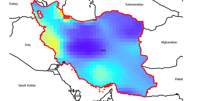
This dataset provides detailed monthly average precipitation data for 31 cities across Iran, covering a span of 120 years from 1901 to 2022. It offers a valuable resource for anyone aiming to understand Iran's historical precipitation patterns. The data can facilitate the analysis of long-term precipitation trends, the assessment of climate change impacts, and support natural resource management initiatives. It is important to note that the data originates from satellite measurements, which may introduce differences compared to ground-based observations, especially in remote or highly clouded regions.
Columns
The dataset includes two primary types of columns:
- date: Represents the specific date for which the monthly average rainfall is recorded. The format is typically YYYY-MM-DD.
- [City Name]: There are 31 columns, each named after an Iranian city (e.g., Ahvaz, Arak, Ardabil, Tehran, Zanjan). These columns contain the average monthly rainfall for the respective city, measured in millimetres (mm). Each city column also provides statistical metadata such as Valid record count, Mismatched entries, Missing entries, Mean rainfall, Standard Deviation, and Quantiles (Min, 25%, 50%, 75%, Max).
Distribution
The dataset is provided as a CSV file, titled 'Rainfall_Iran_19012022.csv', with a file size of 472.97 kB. It is structured with 32 columns and consists of 1464 rows. Each row represents a specific month's data over the 120-year period from January 1901 to December 2022.
Usage
This dataset is ideal for:
- Analysing long-term precipitation trends in various Iranian cities.
- Assessing the impacts of climate change on regional weather patterns.
- Informing natural resource management strategies and planning.
- Supporting academic research in meteorology, climatology, and environmental studies.
Coverage
The dataset's geographic scope covers 31 specific cities across Iran. The time range extends from 1901 to 2022, providing 120 years of monthly rainfall averages. There are no demographic specificities, as the data focuses purely on meteorological measurements. As previously mentioned, the data is satellite-derived, and users should be aware of potential discrepancies with ground observations, particularly in remote or cloud-prone areas.
License
CC BY-SA 4.0
Who Can Use It
This dataset is primarily intended for:
- Researchers: To conduct studies on climate change, precipitation variability, and historical weather analysis in Iran.
- Decision-makers: For strategic planning related to water resources, agriculture, and urban development within Iran.
- Environmental scientists: To monitor and assess environmental patterns and changes over time.
- Students and educators: As a valuable resource for academic projects and teaching related to climatology and earth sciences.
Dataset Name Suggestions
- Iranian City Monthly Rainfall 1901-2022
- Iran Historical Precipitation Dataset
- Monthly Average Rainfall in Iran (1901-2022)
- Iranian Urban Climate Data: Monthly Rainfall
Attributes
Original Data Source: Iran Historical Precipitation Dataset
Loading...
Free
Download Dataset in ZIP Format
Recommended Datasets
Loading recommendations...