Dark Mode

Historic California Wildfires Data
Data Science and Analytics
Tags and Keywords
Trusted By


"No reviews yet"
Free
About
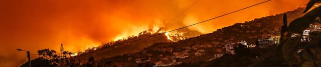
This dataset provides detailed information on wildfire incidents in California between 2013 and 2020. It serves as a valuable resource for understanding the patterns and impacts of these often destructive events. The data helps to identify locations prone to fire threats, determine typical wildfire occurrences, and assess their frequency and severity.
Columns
- AcresBurned: The total acreage of land affected by each wildfire incident.
- Active: Indicates if the fire is currently active or has been contained.
- AdminUnit: The administrative unit responsible for managing the incident, such as CAL FIRE units.
- AirTankers: The number of air tankers deployed as resources for fire suppression.
- ArchiveYear: The year the specific incident data was archived.
- CalFireIncident: A boolean flag indicating whether the incident is classified as a CAL FIRE incident.
- CanonicalUrl: A unique URL associated with the wildfire incident.
- ConditionStatement: Textual descriptions detailing the current condition or status of the fire.
- ControlStatement: Textual information regarding control measures implemented, such as road closures.
- Counties: The name of the county where the wildfire incident took place.
- CountyIds: The numerical identifier for the county.
- CrewsInvolved: The total number of fire crews assigned to the incident.
- Dozers: The number of bulldozer resources deployed.
- Engines: The number of fire engines assigned.
- Extinguished: The date when the wildfire was declared extinguished.
- Fatalities: The reported count of fatalities related to the incident.
- Featured: A boolean flag indicating if the incident is highlighted or featured.
- Final: A boolean flag indicating if the incident's record is finalised.
- FuelType: The type of fuel that ignited or sustained the fire, such as grass.
- Helicopters: The number of helicopter resources assigned.
- Injuries: The count of personnel injured during the incident.
- Latitude: The geographical latitude coordinate of the wildfire incident.
- Location: A descriptive text providing more detail about the incident's location.
- Longitude: The geographical longitude coordinate of the wildfire incident.
- MajorIncident: A boolean flag indicating if the incident is deemed a major event.
- Name: The specific name given to the wildfire.
- PercentContained: The percentage of the fire that has been contained.
- PersonnelInvolved: The total number of personnel assigned to the incident.
- Public: A boolean flag indicating public availability of information regarding the incident.
- SearchDescription: A description used for search indexing.
- SearchKeywords: Keywords associated with the incident for search purposes.
- Started: The date when the wildfire incident began.
- Status: The current operational status of the fire, e.g., Finalised or Inactive.
- StructuresDamaged: The count of structures that incurred damage.
- StructuresDestroyed: The count of structures that were completely destroyed.
- StructuresEvacuated: The count of structures that required evacuation (this column is entirely missing data).
- StructuresThreatened: The count of structures that were at risk from the fire.
- UniqueId: A unique identifier for each wildfire incident record.
- Updated: The date of the last update to the incident record.
- WaterTenders: The number of water tender resources assigned.
Distribution
The dataset is provided in CSV format and has a file size of 970.62 kB. It comprises 40 columns and contains approximately 1,636 records of wildfire incidents.
Usage
This dataset is ideal for:
- Geospatial analysis to pinpoint high-risk fire zones.
- Time-series analysis to identify seasonal or temporal patterns of wildfire occurrences.
- Risk assessment and disaster preparedness planning.
- Educational purposes to study the characteristics and impacts of wildfires.
- Resource allocation optimisation for fire suppression efforts.
Coverage
The dataset primarily covers wildfire incidents in California that occurred between 2013 and 2020. It includes geographical coordinates (latitude and longitude) and county names, providing a spatial scope across the state. While some date fields might show minimum values from earlier years, the core incident reporting period is within the stated 2013-2020 range.
License
CC0: Public Domain
Who Can Use It
- Environmental researchers studying climate change impacts or ecological changes.
- Government agencies involved in emergency management, land use planning, or environmental protection.
- Data scientists and analysts building predictive models for wildfire behaviour.
- Journalists and public policy analysts reporting on or developing policies related to natural disasters.
- Students and academics for educational projects and research.
Dataset Name Suggestions
- California Wildfire Incidents (2013-2020)
- California Fire Events Database
- Historic California Wildfires Data
- California Wildfire Statistics
- CAL FIRE Incident Records
Attributes
Original Data Source:Historic California Wildfires Data
Loading...
Free
Download Dataset in CSV Format
Recommended Datasets
Loading recommendations...