Dark Mode

Alphabetical Country Location and Spatial Data
Government & Civic Records
Tags and Keywords
Trusted By


"No reviews yet"
Free
About
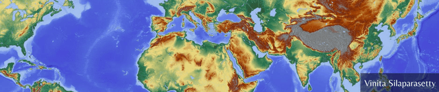
Geographic data visualisation often requires precise mapping of nation-states onto digital canvases. By providing a central repository of latitudes and longitudes for nations across the globe, this resource simplifies the process of creating map overlays. It removes the burden of manual data cleaning by offering a structured set of coordinates that align with official country names to facilitate accurate spatial representation and analysis.
Columns
- latitude: Numerical coordinate representing the north-south position of the country center.
- longitude: Numerical coordinate representing the east-west position of the country center.
- Country: The complete and official name of the nation, arranged in alphabetical order.
Distribution
The information is delivered in a CSV file titled
country-coordinates-world.csv with a compact file size of 8.07 kB. It consists of 244 unique records across three columns. The data exhibits high integrity with 100% validity across all fields and no missing or mismatched entries. It has achieved a usability score of 10.00 and is expected to be updated on an annual basis.Usage
This collection is designed for generating geographic overlays on world maps and creating location-based visualisations. It is ideal for developers building interactive dashboards, researchers plotting international trends, or data scientists working on projects involving spatial deep learning. The structured format allows for seamless integration into Python-based mapping libraries and geographic information systems.
Coverage
The scope is global, covering 244 unique countries and territories. It provides a static snapshot of official country names and their corresponding central coordinates. As the records are sorted alphabetically, the data provides a consistent and organised reference for all recognised nations regardless of their geographic region.
License
Attribution 4.0 International (CC BY 4.0)
Who Can Use It
Data scientists can leverage these coordinates to enhance the spatial accuracy of their visualisations. GIS specialists may find this a useful quick-reference tool for building map layers. Additionally, software engineers can use the official country list to populate drop-down menus or location-tagging features within international applications.
Dataset Name Suggestions
- Global Country Coordinates and Geographic Indices
- Official World Map Latitude and Longitude Registry
- Alphabetical Country Location and Spatial Data
- International Geographic Centroid and Mapping Archive
- Global Mapping Overlays: Official Country Coordinates
Attributes
Original Data Source: Alphabetical Country Location and Spatial Data
Loading...
Free
Download Dataset in CSV Format
Recommended Datasets
Loading recommendations...