Dark Mode

National UK Road Accident Dataset
Government & Civic Records
Tags and Keywords
Trusted By


"No reviews yet"
Free
About
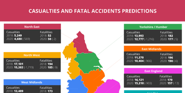
This dataset provides extensive details on road incidents across the United Kingdom, offering critical insights into traffic collisions. It serves as a vital resource for understanding trends in road safety, particularly the ongoing effort to reduce fatalities on UK roads. Although deaths have been on a downward trend since the 1960s, 1,516 lives were still lost in 2020. The data highlights issues with dated road systems, such as those in Liverpool, and points to the potential for implementing further preventative measures. The dataset is particularly thorough, containing information related to geographic areas, weather conditions, vehicle types, casualty numbers, and vehicle manoeuvres.
Columns
The dataset is primarily represented by
accident_data.csv, which includes the following columns:- Accident_Index: A unique identifier for each traffic accident.
- 1st_Road_Class: The class of the first road involved in the accident.
- 1st_Road_Number: The road number of the first road involved in the accident.
- 2nd_Road_Class: The class of the second road involved in the accident.
- 2nd_Road_Number: The road number of the second road involved in the accident.
- Accident_Severity: The severity of the accident, categorised as "slight", "serious", or "fatal".
- Carriageway_Hazards: Observations of any hazards present on the road at the time of the accident, such as animals or pedestrians.
- Date: The specific date when the accident occurred.
- Day_of_Week: The day of the week the accident occurred.
- Did_Police_Officer_Attend_Scene_of_Accident: Indicates whether a police officer attended the scene (Yes, No, or reported via self-completion form).
- Junction_Control: Details the type of controls in place to manage traffic at a junction.
- Junction_Detail: Describes the type of junction at the accident location.
- Latitude: The latitude coordinate of the accident location.
- Light_Conditions: The lighting conditions at the time of the accident.
- Local_Authority_(District): The district council jurisdiction where the accident took place.
- Local_Authority_(Highway): The highway authority responsible for the area of the accident.
- Location_Easting_OSGR: The Easting grid reference for the accident location.
- Location_Northing_OSGR: The Northing grid reference for the accident location.
- Longitude: The longitude coordinate of the accident location.
- LSOA_of_Accident_Location: The Lower Layer Super Output Area where the accident occurred.
- Number_of_Casualties: The total number of people killed or injured in the accident.
- Number_of_Vehicles: The total number of vehicles involved in the accident.
- Pedestrian_Crossing-Human_Control: Indicates if a human-controlled pedestrian crossing was present.
- Pedestrian_Crossing-Physical_Facilities: Information about physical pedestrian crossing facilities at the scene.
- Police_Force: The police force responsible for the area where the accident happened.
- Road_Surface_Conditions: The condition of the road surface at the time of the accident.
- Road_Type: The type of road where the accident occurred.
- Special_Conditions_at_Site: Other contributing factors at the site, such as oil on the road or faulty traffic lights.
- Speed_limit: The posted speed limit at the accident location.
- Time: The time the accident took place.
- Urban_or_Rural_Area: Specifies if the accident location was an urban or rural area.
- Weather_Conditions: The prevailing weather conditions at the time of the accident.
- Year: The year in which the accident occurred.
- InScotland: A boolean indicating if the accident occurred in Scotland.
Distribution
The dataset is provided as two CSV files:
accident_data.csv and vechile_data.csv.accident_data.csv: Contains approximately 1 million records, with each line representing a unique traffic accident. This file is about 300.32 MB in size. The date range for this file is 2005-2017.vechile_data.csv: Contains approximately 1.6 million records, with each line representing the involvement of a unique vehicle in a unique traffic accident. The date range for this file is 2004-2016. Both files can be linked using theAccident_Indexcolumn, which serves as a unique traffic accident identifier.
Usage
This dataset is ideal for a variety of analytical and research purposes. It can be used to:
- Identify patterns and trends in UK road traffic collisions.
- Analyse factors contributing to accident severity and frequency.
- Develop and evaluate road safety interventions.
- Conduct geospatial analysis to pinpoint accident hotspots.
- Inform public policy aimed at reducing road fatalities and injuries.
- Support academic research on transportation safety and urban planning.
Coverage
The dataset covers road incidents across the United Kingdom. It includes geographical coordinates (latitude, longitude, OSGR Easting/Northing) and details related to local authorities, allowing for spatially-aware analysis.
- Time Range: Data for accidents in
accident_data.csvspans from 2005 to 2017, whilevechile_data.csvcovers 2004 to 2016. The UK government typically compiles and disseminates this data once per year. - Demographic Scope: The data broadly covers road users and vehicles involved in collisions across various regions of the UK.
License
CC BY-NC-SA 4.0
Who Can Use It
This dataset is valuable for:
- Road Safety Analysts: To identify high-risk areas and factors.
- Urban Planners: For designing safer road infrastructure.
- Transport Authorities: To monitor road safety performance and implement improvements.
- Researchers and Academics: For studies on traffic dynamics, risk assessment, and policy effectiveness.
- Government Bodies: To inform public safety campaigns and legislative changes.
- Insurance Companies: For risk assessment and policy development.
Dataset Name Suggestions
- UK Road Traffic Collisions Data
- United Kingdom Traffic Incident Records
- National UK Road Accident Dataset
- British Highway Safety Data
- UK Department of Transport Road Collision Data
Attributes
Original Data Source: National UK Road Accident Dataset
Loading...
Free
Download Dataset in ZIP Format
Recommended Datasets
Loading recommendations...