Dark Mode

Daily Water Levels and Discharge of Lake Kariba
Environmental Monitoring
Tags and Keywords
Trusted By


"No reviews yet"
Free
About
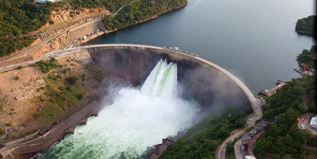
Monitoring the hydrological status of the world’s largest artificial reservoir by volume offers vital insights into water management and energy production in Southern Africa. Lake Kariba, situated on the border of Zambia and Zimbabwe, serves as a critical resource along the Zambezi River. This information tracks the reservoir's levels and storage capacity following the historical filling of the Kariba Gorge, providing a detailed picture of its environmental and operational state over a recent multi-year period.
Columns
- date: The specific calendar day for each daily recording.
- lake_level: The height of the reservoir surface measured in metres.
- usable_storage: The percentage of the reservoir's capacity that is currently available for operational use.
- live_storage: The volume of active water storage expressed in billions of cubic metres.
- turbine_discharge: The rate of water flow passing through the power-generating turbines, measured in cubic metres per second.
- spillage: The volume of water released through spillway gates, measured in cubic metres per second.
- total_outflow: The combined volume of water leaving the reservoir via all exit channels, measured in cubic metres per second.
Distribution
The data is delivered in a CSV format titled
kariba_reservoir_data.csv with a file size of 48.53 kB. It consists of 1,155 unique daily records, maintaining a high integrity with 100% validity across all primary fields and no missing values. This is a static resource with no further updates expected.Usage
This resource is ideal for conducting time-series analysis on water level fluctuations and storage trends within large-scale reservoirs. Analysts can use these metrics to model the relationship between lake levels and hydroelectric discharge or to study the environmental impact of water management strategies within the Zambezi River basin. It also serves as a robust foundation for building predictive models regarding water availability and seasonal reservoir behaviour.
Coverage
The geographic scope is focused on Lake Kariba, located 1,300 kilometres upstream from the Indian Ocean on the border of Zambia and Zimbabwe. Temporally, the records reflect the state of the reservoir daily from 1 January 2020 to 28 February 2023. The data represents the hydrological outputs and storage metrics managed by the Zambezi River Authority.
License
CC0: Public Domain
Who Can Use It
Environmental scientists and hydrologists can leverage these figures to understand the long-term sustainability of the world's largest man-made lake. Energy sector analysts may find the discharge and storage data useful for benchmarking hydroelectric performance. Additionally, data science students can use the structured time-series records to practice statistical analysis, trend forecasting, and seasonal mapping.
Dataset Name Suggestions
- Lake Kariba Reservoir Hydrology: 2020–2023 Time Series
- Zambezi River Authority: Kariba Dam Outflow and Storage Records
- Daily Water Levels and Discharge of Lake Kariba
- World's Largest Artificial Lake: Hydrological Performance Data
- Kariba Reservoir Environmental and Storage Metrics
Attributes
Original Data Source: Daily Water Levels and Discharge of Lake Kariba
Loading...
Free
Download Dataset in CSV Format
Recommended Datasets
Loading recommendations...